
Community, Diversity, Sustainability and other Overused Words
Community, Diversity, Sustainability and other Overused Words
Large areas still remain closed to residents, as stubborn Woolsey Fire burns
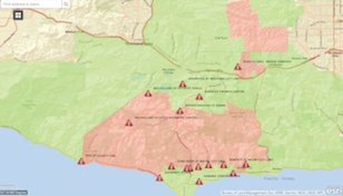
Map from Cal Fire website shows areas being repopulated--mostly east of Las Virgenes Road
The Los Angeles County Sheriff's Department announced Sunday evening that it would allow the repopulation of most areas impacted by the #WoolseyFire - effective Monday, November 19, 2018 at 9:00 A.M.
Approximately 6,400 firefighters covering 617 fire engines, 91 dozers, 159 hand crews, 68 water tenders, 34 helicopters and numerous firefighting air tankers from throughout the state, along with numerous out-of-state resources, are still battling two large wildfires in California. These wind-driven fires have burned more than 247,949 acres and destroyed an estimated 17,350 structures.
In Northern California, locally gusty northeasterly winds over portions of the eastern foothills, Western Plumas mountains, and west slopes of the Northern Sierra Nevada continue today. With combined low humidity and dry fuels, this will produce critical fire weather. Winds will decrease later today as wet weather develops around the middle of the week. The Air Quality Alert is in effect due to smoke impacts from surrounding wildfires for San Joaquin, Stanislaus, Merced, Madera, Fresno, Kings, Tulare, and valley portion of Kern counties. This Air Quality Alert is in effect until the fires area extinguished. In Southern California, warm and dry today with light offshore winds and low afternoon humidity. The strongest easterly winds will be in the mountains passes and foothills from 15 to 25 mph. Fire weather concerns will be elevated in these areas. Gradual cooling Tuesday through Thursday as a Pacific trough moves inland bringing increasing humidity. This system will also bring a chance for light rain Wednesday night and Thursday.
The notice from the Sheriff's Dept. says:
The following areas inside of the City of Malibu will be opened beginning at 9:00 A.M. on Monday: This will include the following areas of the Malibu Colony Cove neighborhood:
o north of the ocean
o south of Malibu city limits
o west of Guernsey Avenue
o east of Ventura County Line
The link below can be used to assist the public in determining if their property is in an area that has been repopulated: https://goo.gl/sUCR5v
Simply visit the link and enter an address for the #WoolseyFire area in the search field and press enter. You can then scroll out on the map to determine if the indicated area has a red or green background. Red indicates the area is still closed and unsafe to return. Green indicates the area is open for repopulation. In addition to the map, the below written descriptions of the areas to be opened has been provided.
The Fire Incident Command continues to monitor the active fire areas, as well as those areas remaining closed due to critical infrastructure concerns or safety hazards. Any future information pertaining to safety conditions and repopulation will be updated at the following
link: http://www.LACounty.gov/WoolseyFire/
The Los Angeles County Sheriff's Department have a strong presence in the repopulated and evacuated areas for the next several days to ensure the protection of our residents and their property. All other road closures and evacuated areas for the #WoolseyFire remain in effect.

Reader Comments(0)