
Community, Diversity, Sustainability and other Overused Words
Community, Diversity, Sustainability and other Overused Words
Warm Gulf of Mexico will contribute to severe weather
The Weather Network's forecast for the months of March, April and May.
The Weather Network's team of meteorologists have just released their spring forecast for the months of March, April and May.
Spring weather is already off to a quick start east of the Rockies. However, winter weather will make a comeback at times across many regions. The clash of the seasons, along with a very warm Gulf of Mexico will contribute to the most active severe weather season since 2011.
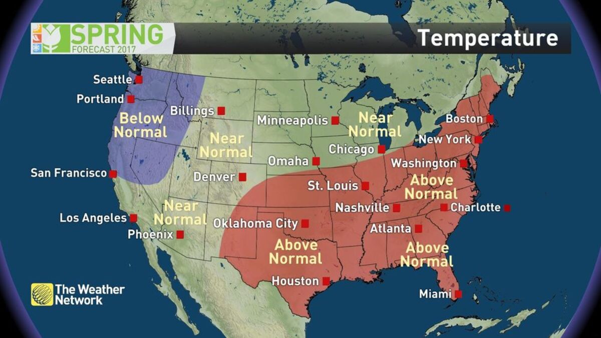
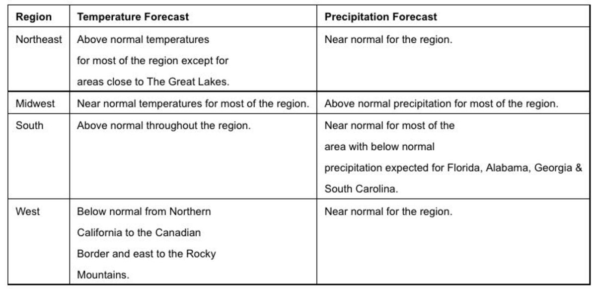
Overall, much of the eastern and southern US can expect above normal temperatures to dominate the spring season. However, the warm weather in combination with a trend towards drier weather during late spring may exacerbate the existing dry conditions heading towards summer. In contrast, a wet spring is expected across the north central US.
Across the northern tier of the States, the early taste of spring will be interrupted by periods of wintry weather through late March. Quick shots of cold weather deep into the southern U.S. are also a concern given the early start to the growing season. The colder weather will be most persistent across the Pacific Northwest. The northern third of the country will have to wait until the second half of spring for persistent warmth, which is typical for this region.
"One of the keys to seasonal forecasts is looking back to years in the past that had similar weather and ocean temperature patterns. In particular, we look to the tropical Pacific Ocean, which is one of our primary drivers of weather patterns around the world. The pattern heading into this spring is unlike anything that we've seen during the past 75 years of record keeping," said Chris Scott, Chief Meteorologist with The Weather Network. "It is evident that another significant El Niño event is developing. Such a quick return to El Niño after a brief and weak La Niña, and just a year after one of the strongest El Niño events on record, leaves us with a unique global pattern."
El Niño, characterized by warmer than normal Equatorial Pacific Ocean waters and La Niña, cooler than normal waters in the same area are major factors in the overall global weather pattern, no matter the season. The most recent El Niño in 2016 was one of the strongest on record and all indications are pointing to another developing El Niño. This provides for a season with heightened uncertainties since effects from the previous El Niño continue to linger.
Looking ahead to the summer months, temperatures are forecast to be above normal for most of the country. Overall, the Atlantic hurricane season is expected to produce fewer storms than many recent years. However, much warmer than normal ocean water temperatures in the Gulf of Mexico and along the Eastern Seaboard elevates the threat for any storm that does makes landfall to be highly impactful.
Complete Spring Forecast details, including regional breakdowns, maps and charts are available at http://www.theweathernetwork.com. To access detailed weather information whenever needed visit http://www.theweathernetwork.com or download The Weather Network app from Google Play or iTunes.
About The Weather Network:The Weather Network is a leading provider of weather and weather-related forecasts and reports on all platforms. Celebrating 27 years, parent company Pelmorex Media Inc., in addition to US operations also operates in Canada, Spain, the U.K., Germany and Ireland under the banners The Weather Network, MétéoMédia, Eltiempo.es and Wetterplus.de. The Weather Network and its French counterpart MétéoMédia are Canada's most popular weather and information services on TV, web and mobile apps. Eltiempo is Spain's leading multi-platform weather information provider. Pelmorex also operates Canada's National Alerting Aggregation and Dissemination System (Alert Ready) which aggregates and distributes emergency alerts issued by authorized government agencies.

Reader Comments(0)